 Live Music Archive
 Librivox Free Audio
 Metropolitan Museum
 Cleveland Museum of Art
 Internet Arcade
 Console Living Room
 Books to Borrow
 Open Library
 TV News
 Understanding 9/11
tv ABC News Good Morning America ABC October 28, 2012 7:00am-8:00am PDT
7:00 am

good morningeric good morning, america. this morning, tracking the super storm. sandy is massive and on the march up the east coast, about to become a hideous hybrid of hurricane and winter storm. more than 50 million americans in the crosshairs. where will this thing hit? how long will it last? our extreme weather team has the very latest. bracing for impact. could this storm shut down america's largest city? while power companies are calling in the cavalry from all the way out in the heartland, millions are told they could lose electricity for up to ten days. the perfect political storm. could sandy tilt the balance in the astonishingly close race for the white house? it's driving thousands to the polls for early voting and causing the campaigns to rejigger their plans for the all-important stretch run. and tsunami warning.
7:01 am

a magnitude 7.7 earthquake off the west coast triggers a tsunami warning for hawaii. we'll have the latest. hey, good morning, everybody. we are watching this developing story in the hawaii tsunami warning. the tsunami downgraded but the threat not completely over. a live report in just a few minutes. frnts but we are going to start here, of course, with the super storm, which one meteorologist has called part hurricane and part nor'easter, all trouble. take a look at sandy from space. this beast of a storm is expected to have tropical storm-force winds that extend out more than 500 miles from the center. >> that's right. states of emergency have been declared up and down the east coast in eight states so far plus the district of columbia. a third of the country is expecting some combination of high winds, rain and heavy snow.
7:02 am

and the national guard has mobilized 60,000 troops in 9 states to assist local authorities if needed. and take a look at this staggering number that we put up on the screen behind us. 261,000 homes, more than $80 billion in real estate, could see storm surge damage if sandy hits as a category 1 hurricane which is a real possibility. >> that's right, and, of course, the big question this morning is when and where will this mega storm hit land? our sam champion has been tracking sandy and has the very latest from one of the most vulnerable spots in stork city from battery park in lower manhattan. good morning to you, sam. >> good morning, bianna and dan. we're right here and you can see new york harbor behind us. we'll be able to see how wide this band of water is. that's why folks are concerned. all of this extra water gets squeezed through there and then hops up over where we're standing potentially flooding. that's just one of the problems there. the latest information from the hurricane center, let me just read this to you, the top line as it comes out,
7:03 am
sandy expected to bring life-threatening storm surge from the mid-atlantic coast including long island sound and new york harbor. winds are expected to be near hurricane force at landfall. that's the very latest from the hurricane center. let's get to the maps and show you exactly where this storm is. by the way, satellite will show you that this is the largest cloud mass we've seen from a tropical system in the atlantic basin. it's really and truly it's one of the top two or three we've seen if you measure these clouds. they go all the way from the carolinas well up past maine into canada, the scope of those clouds. quick look at the path here. that has not changed. hurricane center still feels it will cruise up the coastline. right now it's parallel to the carolinas and creating an awful lot of storm surge and flooding right along the coast of the carolinas, and the biggest problem here is this storm makes a left-hand turn and comes onshore. the wind speeds, we've got tropical storm-force winds more than a thousand miles across there. this thing is really going to have a lot of wind damage and a large area, so don't just focus on where the storm makes landfall.
7:04 am
that's just for coastal surge, and the rain, it's not just about where the storm makes landfall it's rain all over from the mid-atlantic well inland all the way up into the northeast. now we've been talking about where that storm is and off the coastline and effects up the eastern seaboard. let's show you a picture. you're not going to believe it. it's a couple hundred miles away from where our matt gutman is and take a look at the conditions he's in right now. good morning, matt. >> reporter: good morning, sam. that's right. that storm is over 250 miles away, and still it has been howling through here. this weather is intensifying. just over the past couple of hours, and the folks here who are used to seeing inclement weather, haven't seen anything like this in a very long time. this is this strange hybrid, and what you're seeing right now, this is sea foam being blown in from who knows how far out. the ocean is so riled up, and it is so intense up here. i'll get to higher ground for a sec that it's just whipping all these waves up and tossing this
7:05 am
foam onto the shoreline. we're hearing of buoy hits of 32 feet, 32-foot waves out in the ocean, not too far away from where we are. the winds are gusting at about 60 miles per hour. it is extremely, extremely sloppy, and this storm surge over the past 12 hours or so has been absolutely relentless pushing everything up on shore. i'm at a pier right now, and maybe with the second camera you can see the other side of the pier. the beach used to be about 150 yards that way. it has been pushing off onshore all morning long, and it will stay like this for quite a while. this is some pretty serious stuff. now to ginger who is in new jersey. ginger. >> we've got this slipped under my doorway. we stayed in a casino hotel. it says you have to get out by 4:00 p.m., a mandatory
7:06 am

evacuation. atlantic city has only shut down from weather in its 34 years of legalized gambling three times including this one. so only twice before irene being one of them. here's why. the storm is still 24 to 36 hours away. the flow starting to flow up over that and you see this barrier, it could easily with a 10 to 20-foot rise wave up and there's the iconic boardwalk some being boarded up so taking it very seriously not only here in atlantic city but through the barrier islands up the jersey shore. and that's who it's going to hit. right to those graphics. i need to show you who will get what and when. that storm surge very important. i want to show you exactly what to expect here. 6 to 9 feet in that red area or 4 to 8 feet, excuse me, in that magenta area and then the blue still, you've got a 1 to 3-foot surge and all coming from the southeast end to the northwest. let me show you the wind forecast, because sam showed you how big and how many people will be involved in this. but look at how high those wind speeds go, 60 to 80 miles per hour, pittsburgh, d.c., new york city and boston in that red
7:07 am

zone, and, of course, it extends all the way back to the eastern great lakes too. we'll watch the storm not only here from atlantic city but all across the eastern seaboard and i'll have much more coming up. by the way, this storm different because i have a winter coat on under the extreme team jacket to cover a hurricane. >> yeah, it's funny, because i'm layered up, as well, ginger, and this one has that cold air pulling into it so hurricane-force winds, very, very cold temperatures. ginger, something else i want to talk about that we haven't talked a lot about this morning before we even get to the preps new york city is making. you think of new york city and the entire east coast as this big sky high line, it's just big, big, big buildings all along the coastline, skyscrapers and one world trade, i'm looking at it right there. there's a lot of construction on the top of those buildings. that's a problem for 70, 75-mile-per-hour winds blowing things off the building. in this area you don't need to be walking around because debris will be flying, not just trees and not just things that you think are harmless like trees,
7:08 am
but big chunks of construction debris could easily be flying through this area now the other travel problems. now we know we're going to have power outages, and we know we're going to have this water moving onshore and some of that water, we're about three feet above where the water is in new york harbor. so if that water gets in, we're talking about problems with flooding in subway systems, new york city is definitely aware of this, and they're getting ready for it. we're under a state of emergency and they want everybody prepared today for a monday storm boarding up homes and buildings. >> i'm cooking. i'm thinking we're not going to eat for the next six days. >> and sweeping sewer catch basins to help drain floodwaters. >> this is a dangerous storm, but if it would strengthen unexpectedly or change its path it could do a lot of damage and you could be at risk. >> new york city transit officials are preparing for a possible shutdown of the subway
7:09 am
system, the largest rapid transit system in the world. >> if it's shut down while i'm in the city, that's a problem. >> sandy can potentially create a storm surge larger than last year's hurricane irene overtopping the floodwalls, possibly filling the subway tunnels with water. >> lower manhattan is the most vulnerable place to a storm surge. we're closing public transit should the need arise. >> there's no doubt about the fact that the hurricane center expects this to be really bad weather for a large part of a huge population center, anywhere from central new jersey, that includes philadelphia, atlantic city, new york city, all the way up toward boston. so, dan and bianna, it's something that we've got to pay attention to all day today into tomorrow and tuesday. >> sam, i've got to ask you. every time we have a story like this, we run into complacency now, especially new york city where hurricane irene last year wasn't so bad in the city itself.
7:10 am
what would you say to people who are attempting to write this off? >> i want to remind folks about that hurricane. it was a bad storm, dan. it just didn't deliver the wind damage that new york city expected. and the surge wasn't really here, but if you look inland where it was catastrophic flooding and so many folks were affected by that storm, it was a terrible storm. it just wasn't for the big population center of new york city, and this one, the hurricane center says will have all of those elements focused on these big population areas, new york city is one of them with the storm surge, with the high winds, with the flooding rain. they say they think this thing will really affect it and i'm going to believe them and i'll just everybody to be prepared. >> all right. better safe than sorry. all right, sam champion, thank you. and one of the biggest worries ahead of this monster storm is the potential for massive power outages. officials are warning those outages could last for more than a week. crews are already in crisis mode working overtime doing their best to keep the lights on.
7:11 am
abc's david kerley has more from rehoboth beach, delaware. good morning, david. >> reporter: good morning, bianna. you know, you've heard my colleagues talking about the storm surge. they're worried about it here in delaware. in fact, it's a mandatory evacuation and the problem is this, the lights, will they stay on for millions of americans? this is what power companies are worried about. last year irene left 7 million homes without power. so even before sandy's hurricane winds and rain, utility crews are out trimming tree, putting crews in place. >> it looks pretty ominous. >> reporter: vince mahone has been with the utility that serves south jersey including atlantic city for 28 years and has never seen a storm like this and knows a lot of his customers are going to lose electricity. >> the best thing is to be prepared and i think that's what we are. we're prepared for what the worst can bring. >> reporter: new jersey's governor declaring a state of
7:12 am
emergency, warned residents they could be without power for a week to ten days, and chris christie says he's worried that residents might put generators indoors or run extension cords in a haphazard way to get some electricity. >> that's a good new jersey rule, if it looks stupid, it is stupid. >> reporter: already crews from mexico to iowa are in their trucks driving to the east coast in front of sandy's wrath. so how bad could it be? believe it or not, this guy thinks he has an idea, a researcher at johns hopkins has put together a model predicting how many of us may lose power. remember, irene left 7 million without electricity. >> our model is suggesting roughly 10 million. >> reporter: 10 million who could be without power for a week or more. so we're talking about 50 million people may feel the effects of this storm. that means one in five potentially could see their lights go out. so if you're inland, and you don't think that these waves and this coastal impact is going to affect you, think again, it
7:13 am

could be a bad one, dan and bianna. >> it will go well inland. we know that. from the meteorologists. david kerley, thank you for your reporting this morning. meanwhile, 5,000 miles to the west there is another breaking story we're watching closely right now. a massive earthquake off the west coast triggered a tsunami warning for hawaii downgraded to an advisory, our worst fears quelled for now at least. now our affiliate in miami reports. >> reporter: very serious in hawaii. the civil defense calling for an evacuation all low-lying areas because of a tsunami threat in our area that's generated by the 7.7 magnitude earthquake in canada. we're expecting waves of up to three to six to seven feet. haven't seen that materialize yet, even though they are seeing some of those tsunami waves come in at a couple feet or so. still a fairly serious situation out here with what may happen in some of the bays. it's still going to be a long night tonight. still going to have to wait at least a couple more hours before they can even consider lowering that advisory, but it appears
7:14 am

it's not going to be as bad as they once predicted. we'll send it back to you. >> a lot going on on this sunday morning. let's get it back out to sam. sam, talk us through the science here. how much longer should they be nervous in hawaii this morning? >> well, the good news is, dan, that they did everything right here. i mean when you get a 7.7 on the western coast of canada, and you've got nothing but open water between it and hawaii, and this was a subsidence kind of quake, which means the plates are lying underneath each other. the other kicks the plate up. acts like a splash or flipper and creates a wave, if not just one wave, they thought it was four waves or think it's four waves as we've been counting them and have the tsunami warning center. all the buoys mean that those at the coastline are able to
7:15 am

monitor the lift in the water, so the buoys got a tail underneath it and the sensor knows how high that wave is. we know they could have been very high. they could have been eight-foot waves but they weren't. anywhere from 6 inches to 2 feet to 4 feet as we've been able to monitor them. the good news. we've seen them move through and usually more than one and been able to watch them go and in this case able to say, hey, we feel pretty good about it. if there's not any more activity then people can relax a little bit now and watch the water kind of move toward the coastline, whatever is left of it but the very good news is they did everything right and set off the warnings as soon as there was a 7 or above. normally the bad tsunamis will be when you hear the numbers 8 or 9 then you know you've got one heck of a wave. in this case a 7, you still want people to be prepared because you just don't know if those waves will pile up on each other. dan, bianna? >> let's bring in george stephanopoulos, host of "this week" for how this is going to affect the elections. a huge political ramification going into nine days until voters go to the polls.
7:16 am

how do any affect this? >> we've seen both governor romney and president obama have to cancel events, obama in virginia, and adjust their schedules. president obama canceling an event in colorado. that's one big impact right now and also it will affect their efforts to get out the vote and early voting didn't seem to have much effect on the early voting in florida yesterday but could complicate efforts to get out the vote in virginia and ohio, two other key states that will be impacted by the storm and finally if this storm is as bad as it seems to be right now, it could block out the closing arguments of these candidates in the last nine days. >> in some ways this is the real october surprise. i wonder if you're the president, how do you manage campaigning because the job is truly on the line with governing and managing perhaps a large disaster response. >> you show you're in touch. that's why the president put out photos of him talking to the director of the federal emergency management agency and he also is returning to the white house tomorrow afternoon, as i said, canceling some events. the biggest problem right now, if he makes any mishandling of the storm could affect the final days of this race more than any other factor.
7:17 am

>> and in nonweather news a bit of a surprise. "the des moines register" largest newspaper in a swing state there endorsed romney. the first time that newspaper has endorsed a gop candidate. how big of a deal is that? >> iowa is a key state. it's part of barack obama's midwestern fire wall. he needs to win iowa, wisconsin and ohio if governor romney wins both florida and virginia and this could have an effect. it could affect independent swing voters in iowa right now. the obama campaign says they are ahead in iowa right now. this could make some difference in the end, and it reinforces the argument that romney is making headway. he is best positioned to make the bipartisan compromises america needs. that echoes romney's message in these closing days. >> just over a week to go and it just got even more interesting. george stephanopoulos, thank you. george, by the way, has a huge show this morning. his guests include stephanie cutter from the obama campaign and the former house speaker newt gingrich. now let's get a check of the morning's other top news. there is other news happening. >> hi, good morning, everyone. another potential attack on a u.s. embassy may have been
7:18 am

thwarted and police in indonesia say they have arrested 11 people suspected of planning attacks on a range of domestic and foreign targets in jakarta. mriz seized bombs, explosives and ammunition. new details of the new york city nanny who allegedly killed two young children. friends and relatives of that nanny say that ortega had been unraveling complaining of money troubles, losing weight and seeking psychiatric help. ortega is still in the hospital with self-inflicted knife wounds. she's not yet been charged. and the young man known as victim number one in the jerry sandusky sex abuse scandal is speaking out against bullying. aaron fisher spoke at a rally saturday outside the pennsylvania high school that he was bullied out of last year. he was trying to help put an end to bullying. he is trying to put an end to bullying and help other abuse victims come forward. sandusky, the former penn state football assistant coach, was sentenced up to 60 years in
7:19 am

prison for his crimes. and seven people were injured when a town car crashed into a park car in los angeles sending both of them plunging 20 feet off an elevated parking lot. none of the injuries is considered life-threatening. police say the driver thought he was in reverse when he accelerated instead. and finally, the san francisco giants are just one win away from winning the world series. the giants scored two early runs last night. that's all they would need shutting down the tigers of detroit for the second straight time, not shutting them out, but the giants go for a sweep and their second title in three years tonight. and as professionals we strive for objectivity, neutrality in our news, but as a native san franciscan, i wouldn't mind seeing the giants win. >> wouldn't mind? come on. putting it mildly. >> a smile on your face. thanks, ron. let's go back out to sam champion with a look at the nation's weather. sam? >> hey, good morning, bianna, dan. good morning, ron. everybody, the extreme team is
7:20 am
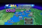
out. ginger is a couple hundred miles down the coastline so let's get you your weather. in case you're just waking up the storm is on track, and the storm we're talking about is sandy. it is to continue moving up the coastline, forecasters still expect it will make that left-hand turn monday into tuesday being a bad storm. anywhere from where you see those areas shaded in red and goes all the way up the coastline. i would include this not to be just a coastal system but a problem with rain well inland and inland power outages expected. with the cold air also getting involved, numbers like this, frost and freeze warnings are out. you're waking up with 40 degrees in dallas. 29 in springfield. little rock, 28. quick look at the big board and see the rain and snow in the northwest today. if you're looking for a warm, dry spot, we say phoenix sounds good. dallas, up to about 64 degrees after that early morning chill and even feeling that cool air in atlanta. this is the first big push of cold air this season through a
7:21 am
big part of the country getting involved in the coastal system, big part of the country getting >> your extreme weather team is out in full force this morning covering sandy along the shoreline. ginger zee in atlantic city. i'm right here in new york. dan and bianna? >> we have much more from sam coming up here on "gma." our extreme weather team all over the super storm. the very latest on when and where sandy will make landfall and then the big question, what happens from there? plus, sandy's ripple effect on travel. hundreds of flights already
7:22 am

canceled possibly for days. and the mess that this storm could make for travel across the country could be terrible. >> we should say we also have a little bit of lighter fare this morning. check this out, a gaggle of puppies and one cat all trying to get inside the house. which one of these varmints will figure it out and how. we'll show you coming up on "fixation" on this sunday morning. keep it here on "gma" this sunday morning. [ male announcer ] behold the joy, bliss and total delight that can only come from having someone else pay your mortgage for an entire year... this is what you'll experience if you win the quicken loans skip-a-year mortgage sweepstakes. up to five winners will get to skip a year of mortgage payments... courtesy of quicken loans. enter often at skipayear.com for more chances to experience...this... the skip-a-year mortgage sweepstakes. one more way quicken loans is engineered to amaze!
7:23 am

because four out of five dogs over the age of three develop gum disease, and tartar buildup is a contributing factor. [ dog ] or new dentastix fresh. clinically proven to fight tartar and now with added ingredients to fight dog breath, too. and now with added ingredients nayou just mix together a few. simple ingredients, add a bit of heat, and "voila."
7:24 am

so to make truvia baking blend, we shared one of nature's most surprising secrets: sweetness from the stevia leaf. for a blend of truvia natural sweetener and sugar that bakes and browns like sugar, with 75% fewer calories per serving. from nature, for sweetness.
7:25 am

coming up on "good morning america," much more coverage of hurricane sandy as it approaches the eastern seaboard. as you can see there, it's already hitting the ocean there, and that's in north carolina, nags head, north carolina, you see sea foam. up to 10 million people could be left without power for days affecting a third of the nation. >> 50 million people in the crosshairs this morning another big issue we'll talk about coming up, the travel delays, they have already started and we're pretty sure it's only going to get worse. keep it here on "gma" this sunday morning. more coming up. ing america" this sunday morning. more coming up.


7:30 am

and you are looking at a live picture of nags head, north carolina, as the country anticipates and braces for hurricane sandy. this is a monster of a storm. you see the sea foam developing there and spraying towards the camera. it's going to be cold there, as well. not good news. >> this is just the early signs there. you can just see matt gutman walking into the frame. this is the early sign. this is rehoboth beach. we're expecting days and days of much more worse. good morning, america. i'm dan harris alongside bianna golodryga -- the first time i ever mispronounced your last name. bianna golodryga. it's october 28th, and we are talking all about that epic super storm this morning.
7:31 am

in a few moments we're going to tell you about the travel delays that this storm has caused. it hasn't even made landfall but hundreds of flight cancellations and it's threatening to cause a domino effect all throughout the country. amtrak, causing delays, as well with the train service but first we want to get a real sense of where the storm is now and what it's going to do when it makes landfall. as we said, it's marching up the east coast. tens of millions of americans in the crosshairs. >> that's right. our extreme weather team has the very latest starting with sam champion who is in manhattan's battery park city, a low-lying neighborhood that's on high alert. sam? >> yeah, bianna, dan, good morning. you can see why. if you look right behind us, all of that is new york harbor. and where we're standing right now, this water is just about three feet from coming up over where we are. if we're expecting a four to ten-foot storm surge, well, okay, enough said about that. we'll talk about that, amtrak and subway issues. travel, no matter how you're thinking about it, roads, trains, amtrak are susceptible to trees down, power lines down, flooding and road closures like that. even the new york city subway
7:32 am

stations are a little concerned because as we just told you, if you're looking at about three feet of water before it tops the area here, all that water runs where, into subways, and that's their biggest concern, that they may have to close down buses, may have to close down subways. there's a lot of weather problems and a lot of effects from the weather that will be involved in this storm. it's not just the storm surge. it's winds. it's flooding rains and then it's the kick-back more rain running off from wherever that heavy rain is going. so there's a lot -- even that little bit of snow that we think will hit in higher elevations as well. the track of the storm so you're prepared for where it's going. right on track hurricane center hasn't changed much at all in the last couple of updates knowing this thing is curving up the coastline by monday making that turn, they believe, that left-hand turn that would take it on to the jersey shore, central new jersey making landfall from the jersey
7:33 am

shore, central new jersey all the way up toward probably somewhere in long island. but as ginger zee is just about to show you, and she's in atlantic city right now, it doesn't really matter much other than the coastal water effects where this storm is going, and our matt gutman, i will go to matt first, is on the coast in north carolina where the strong effects -- this storm breezed by where matt is and already there's a lot of wind and rain and matt is standing in what looks like sea foam. good morning, matt. >> reporter: breezed by is kind of the right term. that's what's so shocking about the storm. it's about 200 miles off the coast, and still we're getting all of this weather. now, this looks like snow. this is sea foam, and that's how violent the storm is, 200 miles off -- it's kicking up all of this wind and wave action and tossing all of this stuff inland. that's a big concern here. 32-foot waves, and this is just a sliver of what folks farther up north in the mid-atlantic where ginger is are going to see. now, another thing, a lot of folks here are accustomed to storms like this like hurricanes haven't seen, and that's this biting cold that is accompanying it.
7:34 am

i'm wearing multiple leather -- layers of clothing right now. that's how cold it is. it is also so wet. as you said, sam, that combination of wind, rain, all this storm surge coming in pushing up against here, exploding these waves against the pier, it's going to make it very, very complicated, very, very messy for a lot of folks out there. ginger? >> hey, matt. >> reporter: i can't hear you for all the sea foam. >> yeah, i know you can't, matt, but it's important for us to see that picture, and as you pointed out, that storm is 200 miles off your coastline. look how angry that is on that shoreline and realize we're expecting the storm to make a curve and move onshore somewhere near our ginger zee right now in atlantic city. it may be a little north of you, ginger, but as we're pointing out it practically doesn't matter where it makes landfall it's such a big storm with so many problems. >> so, again, sam,
7:35 am
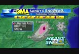
definitely preparing for the worst here in atlantic city. that mandatory evacuation starting at 4:00 p.m. that's all up and down most of the barrier islands and parts of the jersey shore. i do want to mention too something that will be interesting with this storm. a lot of places along the east coast may see record low pressure. atlantic city's record is 960.7. we could easily break that and we'll be keeping you updated on that and then there's a whole other part of the storm, the snow. let's look at that. how much can you expect in parts of the mountains and west virginia especially up to a foot or more. some winter storm advisories and watches have already been posted and we're going to keep an eye on just exactly where that snow falls and when it falls. and that's going to be later in the storm monday and tuesday and also wednesday. dan and bianna? >> we are going to be all over this story for days. as sam was saying, and i think this is worst echoing, it doesn't really matter that much where this storm comes ashore because it is going to merge with a cold front and create a mess. a hybrid disaster-type storm
7:36 am

with -- it's going to be a combination of a nor'easter and a hurricane, so this is going to sit and spin over this part of the country for days. we'll be covering it as we said for days. there's a lot of other news. this morning, let's check in with ron claiborne covering that. >> good morning, everyone. in the news the other big story this morning, the tsunami warning has been downgraded to an advisory. emergency evacuations were ordered after a massive earthquake off of the west coast of canada, but the waves in hawaii were smaller than expected. no damage has been reported. and the super storm, also known as sandy, has both presidential candidates canceling campaign events. president obama is dropping appearances in virginia tomorrow and colorado on tuesday so he can monitor the storm. mitt romney, meanwhile, has canceled events in virginia and instead is going to ohio. and the statue of liberty is, well, scheduled to re-open today as long as the storm doesn't interfere. lady liberty underwent a $30 million makeover that will
7:37 am

enable 26,000 more people to visit the crown of the statue every year. and the first commercial space capsule to deliver supplies is now on its way home much the dragon capsule detached from the space station, it happened this morning now set down to splash down -- set to flash down in the pacific ocean this afternoon. time now for the nation's weather. back to sam champion in lower manhattan. sam? >> hey, good morning, ron. extreme weather team is out covering the most likely hit zones for this storm, sandy. ginger zee in atlantic city. i'm standing here in the battery of new york. now to the other weather. we've got to talk about cold temperatures and also some rain that's moving elsewhere in the country today. so a quick look at where that northwest rain is coming in. seattle, spokane, missoula, pendleton, you're getting rain out of this system that moves in, and it will be more than a little in those higher elevationsment upslope coming off the west coast and pick up 1 to 2 inches of rain moving in there and there will be a little mountain snow involved. a quick look at our flyby today will show you that
7:38 am

all eyes are on sandy. this is a coastal storm that will be a real issue for anywhere from that washington, d.c. -- and these are major cities involved here. washington, d.c., philadelphia, new york city, all the way up to boston. so big areas with big po >> all of america's weather was brought to you by edward jones. i'm very pleased to be a part of the broadcast this morning. ginger zee is just downshore. the extreme team is on it, dan, bianna. >> and we're pleased to have you, sam. thank you. >> coming up on "good morning america," travel nightmare. the super storm marching up the east coast has already forced the cancellation of hundreds of flights and causing a ripple effect across the nation. we'll have an update. and we've got some lighter stuff too coming up in
7:39 am

"fixation." four puppies, one cat and a burning desire to get inside. the way these guys figure this out is hilarious. we'll show you in just a few minutes on "gma" this sunday morning. morning. a few minutes here on "good morning america." [ female announcer ] wake up with your favorite instant coffee same great taste, now with a great new look that can be ready in a... [ pop! ]
7:40 am

♪ folgers instant coffee the taste you love just got more instant. that was me... the day i learned i had to start insulin for my type 2 diabetes. me... thinking my only option was the vial and syringe dad used. and me... discovering once-daily levemir® flexpen. flexpen® is prefilled. doesn't need refrigeration for up to 42 days. no drawing from a vial. dial the exact dose. inject by pushing a button. flexpen® is insulin delivery... my way. levemir® (insulin detemir [rdna origin] injection) is a long-acting insulin used to control high blood sugar in adults and children with diabetes and is not recommended to treat diabetic ketoacidosis. do not use levemir® if you are allergic to any of its ingredients.
7:41 am

the most common side effect is low blood sugar, which may cause symptoms such as sweating, shakiness, confusion, and headache. severe low blood sugar can be serious and life threatening. ask your healthcare provider about alcohol use, operating machinery, or driving. other possible side effects include injection site reactions. tell your healthcare provider about all medicines you take and all of your medical conditions. get medical help right away if you experience serious allergic reactions, such as body rash, trouble with breathing, fast heartbeat, or sweating. with flexpen®... say good night to vial and syringe. ask your doctor about levemir® flexpen. covered by 90% of insurance plans, including medicare. find your co-pay at myflexpen.com.

7:43 am
and there you are looking at a live picture of nags head, north carolina, as that state braces for the impact of hurricane sandy. you can see the sea foam already developing. remember, this is not just a hurricane affecting the state, it's also going to be very, very cold there. not good news for that part of the country. we're also going to show you another live shot from rehoboth beach, delaware, as that state prepares for evacuation. you see construction crews pulling out garbage cans now. the entire eastern seaboard anticipating the wrath of this hurricane. >> and, you know, we just have to say this is so important to keep in mind as they clear away the clutter because they're expecting high winds there to throw things around on the boardwalk. you are just looking at the vanguard of this thing. this has not even started. it will make landfall sometime late monday night, early tuesday morning, and then it will be with us for days. welcome back, everybody. i'm dan harris alongside bianna golodryga, and this epic storm taking aim at the east coast as we said hasn't even hit yet but
7:44 am

it is already wreaking havoc on travel, not just in the east coast but from coast to coast. >> hundreds of flights already canceled. trains stopped in their tracks and, of course, many roads expected to be impassable. joining us now with all the details is abc's john muller. >> it is. "trains, planes and automobiles," funny movie but it's not such a funny reality for anyone traveling in the massive grips of this. the ripple effects will cause problems for the entire nation well clear of the impact zone. let's talk planes, hundreds of cancellations to be exact, 900 flights canceled today. 2500 canceled for monday. almost every major carrier is issuing a flexible change policy allowing customers to change their travel plans without penalty fees due to sandy. now, delta will let people ticketed between today and
7:45 am

wednesday in 15 states wednesday in 15 states to reschedule. united and american have similar plans, as well. if your flight is canceled you're entitled to a full refund. amtrak will cancel some trains beginning today between virginia, chicago, washington, miami, new york, even chicago face cancellations. once again, give amtrak a call if you plan on traveling in these areas over the next few days. new york, the largest city in america could really face a shutdown with commuter buses, commuter trains from around the tri-state area facing shutdowns. cancellations, massive delays and, of course, driving, that will be treacherous, if not impossible, in some areas. fierce winds, poor virusability from those flooding rains, flooded roadways, downed trees and power lines are all expected. best advice, plan on staying home during the worst of it and once again if you're traveling on the skies of the rails, call ahead. time to change travel plans is now. don't wait. the time to act is now. guys? >> great advice, john, thank you, and we'll be right back. look i made a face. awesome.
7:46 am

why don't we make a pumpkin. what do pumpkins look like? what's... like this. you're my pumpkin! what do you think? i made a bat. [ boy ] i made a sword. [ both laugh ] ♪ you're gonna love those. [ female announcer ] carve out some time with your little pumpkins. boo! boo! [ female announcer ] happy halloween... from rice krispies.
7:47 am

looks like your bags didn't make it. we'll send them to your hotel. [ sad music playing ] this is fun. [ sad music continues ] [ knock on door ] your bags, sir. thanks. both: finally! one taste, and you'll understand. enjoy delicious dunkin' donuts coffee anytime. best vacation ever! pick some up where you buy groceries. america runs on dunkin'. nyquil tylenol: we are?ylenol. you know we're kinda like twins. nyquil (stuffy): yeah, we both relieve coughs, sneezing, aches, fevers. tylenol: and i relieve nasal congestion. nyquil (stuffy): overachiever. anncr vo: tylenol cold multi-symptom nighttime relieves nasal congestion... nyquil cold & flu doesn't.


7:50 am

♪ you are an obsession you're my obsession ♪ it looks like from storm coverage to a little absurdity. ron. >> from the world of sports high school football scrimmage, check out this guy at the back, tackles him, he leaps over him. >> nice. >> landing on his feet backwards and goes off down the field. some cynics said it was all staged. the cynics, including our producer, they were right. an at&t viral commercial, but the guy really did jump over. >> that's impressive nonetheless. >> speaking of impressive acrobatics, let me set the scene for you. a bunch of puppies and a cat
7:51 am

trying to get inside. one is able to figure it out and it's the cat oddly enough. proof that cats are superior. >> i like cats. >> and that the dogs benefit. >> america, i like cats. >> freeloading puppies, ladies and gentlemen. >> and a trifecta of acrobatic stories. i have a great balancing act. take a look. it's a musical festival in the uk. this is not staged. this is all real. >> that's trafalgar square, right? >> take a look at what this guy does. >> that looks uncomfortable. >> very good spinning there. >> look. >> a dangerous hobby, ladies and gentlemen. we'll be back with with more storm coverage with george and sam. keep it right here. here's my morning routine.
7:52 am

wardrobe. cute. then new activia breakfast blend. mmm... a great way to help start the day. and it helps regulate your digestive system. new activia breakfast blend.
7:53 am

with over 200 varieties, keurig makes brewing a delicious cup of coffee simple. how does it brew such great coffee? well... inside the brewer are these green fields of coffee, and if you travel up this mountain, there's this huge coffee grinder. and then the coffee lands in this cup and water rushes through. actually, i just press this button.

7:55 am

as you know, big weather story brewing. let's get out to sam for one last final thought, sam. >> and, guys, i just want to show you one more thing. take a look at the skyscrapers here in new york just like the freedom tower there. an awful lot of open construction zones, which means
7:56 am

you don't need to be out in this storm at all. flying debris going to be a real problem with the winds. >> okay. thank you for watching, sam. and keep it at abcnews.com for all the weather updates and "this week with george stephanopoulos" is coming up later this morning.


296 Views
IN COLLECTIONS
KGO (ABC) Television Archive
  Television Archive News Search Service
Uploaded by TV Archive on
